Grenzattraktionen
Defense Trench & Eagle Stones
A Hidden Border
Landgraben (Defense Trench): Since the late Middle Ages, beech hedges and trenches have served as border fortifications, and were also used for forestry surveillance. The Aachen defense trench marked the outer boundary of the Aachen Empire, which emerged between the 12th and 14th century as the successor to the old Aachen royal court. It consisted of a rampart with a trench on both sides; the top of the rampart was planted with a dense beech hedge. The passages through the Landgraben were blocked off at night with beams or barriers, known as “Grindeln.”
The city forest in the south of the Aachen Empire was further enclosed by the Inner Defense Trench, which was also partially planted with a hornbeam hedge. The Inner Defense Trench—and in the northeast of the Aachen Empire the Outer Defense Trench—also served for forestry law enforcement. Carts could only pass through the “Grindeln”, which made it difficult for timber thieves. The hedges along the defense trenches were regularly trimmed to man-height; they spread out to the sides and formed a dense, almost impenetrable thicket.
In the Aachen Forest, the embankment of the Outer Defense Trench has been largely preserved. The trenches, on the other hand, have often been filled in or converted into paths. The Inner Defense Trench has been preserved in sections, but the tree cover is now only visible in very isolated spots.
Eagle Stones: At the beginning of the 17th century the border was redrawn and marked with eagle stones—a few of the 138 that existed at the time still remain in the landscape. The stones owe their name to Aachen’s heraldic animal: eagles were carved into the stones on site by various artists.
Harp Beech Trees & Witch Trees: Through regular pruning and pollarding, the former beech hedge has grown into a row of pollarded beech trees that have intergrown. Even after the end of the Aachen Empire, the hedge was maintained until about 100 years ago by foresters who cut firewood there. Since then the pollarded beech trees have sprouted new growth and developed forms that sometimes appear whimsical. They often take on the shape of harps.
Aachen Empire: The “Aachen Empire” refers to the territory of the former free Imperial City of Aachen. The area encompassed the section of the so-called “Glockenklang” (chiming bells’ sound) which was enclosed by the city walls. This included the districts of Berg, Haaren, Orsbach, Soers, Vaals, Weiden, and Würselen, as well as the Aachen Heath, the Aachen City Forest, and the Aachen Imperial Forest. In total the Aachen Empire covered an area of approximately 9,000 hectares and its border was about 70 kilometers long.
The Aachen Empire emerged between the 12th and 14th centuries as the successor to the ancient royal court of Aachen. The oldest written text from the king (Louis IV) dates from 1336 and records Aachen’s rule over the surrounding villages.
In its early phase the Aachen Empire bordered the Duchy of Limburg to the west, the Austrian Netherlands to the northwest, the Duchy of Jülich to the north and east, and the territory of the Imperial Abbey of Burtscheid to the south.
Later the Duchy of Limburg came under the rule of the Spanish king for over two centuries. The territory’s borders were marked by so-called “eagle stones” bearing the Aachen city coat of arms. The land was secured by a moat lined with a beech hedge and a series of watchtowers (“turrets”).
There were once eight watchtowers. They were positioned in such a way that messages could be sent via smoke or light signals to the “Langer Turm” (tall tower) in the city center. The towers still standing today are Alt-Linzenshäuschen, Beeck, Haus Hirsch, Adamshäuschen, and Orsbach Castle, which presumably also served as a watchtower. The towers provided homes for the foresters. It was their responsibility to keep the forests and land defenses in check. They were also required to report any suspicious movements by soldiers or strangers. From the early 16th century on, the roles of watchmen and foresters were combined in this way.
Discover the defense trench and eagle stones:
Royal Forest & Burgundy Stones
Who is the Lord of the Forest?
In the Middle Ages and well into modern times, forests—with their supplies of firewood and food (fruits, berries)—provided valuable resources for people’s daily lives—and were exploited accordingly. In the southwest of Aachen, the rights to the forest were long disputed: Aachen, Gemmenich, Montzen, Moresnet, and Kelmis all laid claim to it.
In 1611, the Imperial City of Aachen and the government in Brussels signed a treaty regarding the forest areas that had been jointly used up to that point. To settle the dispute, the area in question was placed under the direct custody of the Dukes of Burgundy, giving rise to what became known as the “Königswald” (Royal Forest). Beginning in 1615 it was marked by special boundary stones known as the “Burgundersteine” (Burgundy Stones). These stones did not demarcate the boundaries between different states or municipalities, but rather the boundary between the municipal forest and the royal forest.
The approx. 230 hectares of forest is still known today as the Royal Forest. The emblems and inscriptions on the Burgundy Stones, which were produced in various versions, always faced towards the Royal Forest. Stones depicting the Golden Fleece date from the period of Spanish rule. Stones bearing the Burgundy St. Andrew’s Cross were erected during the period of Austrian rule.
Discover the Royal Forest and Burgundy Stones:
Köpfchen Border Crossing
A Checkpoint Turned Cultural Center
The former Köpfchen border crossing is evolving into a venue for artistic and historical exploration.
The concept of a “border” has been associated with the former German-Belgian crossing for centuries: In 1439, Philip the Good of Burgundy conquered a strip of territory from Aachen’s holdings, which included the Köpfchen district. Since then this place has served as an intersection between different languages and cultures.
The “Köpfchen” border crossing opened in the late 1940s. It was a time when smuggling played a significant role in the economic life of the border region—and border security was correspondingly strict. In the early 1950s, increasing traffic made it necessary to widen the road. At the same time a border guardhouse was built in the middle of the road on the Belgian side, directly across from the main customs building. By the mid-1960s the Belgian customs office at Köpfchen alone employed 24 customs officers and two gendarmes working in shifts, as well as numerous customs brokers in the surrounding freight forwarding offices.
Important Border Crossing
Before the opening of the Lichtenbusch highway toll station in the 1960s, Köpfchen was the most important road crossing between Belgium and Germany—both for passenger and freight traffic. In 1980 the barriers at the crossing were removed. In 1995 the Schengen Agreement came into effect, and the border facilities were decommissioned. The site was at risk of falling into disrepair, and acts of vandalism occurred repeatedly.
Starting in 2000, a new vision for the area emerged: a thesis project by a product designer sparked an artistic and creative exploration of the site and its architecture. This initiative gave rise to the German-Belgian cultural association “Kunst und Kultur im Köpfchen,” (Art and Culture at Köpfchen) or “KuKuK” for short.
Köpfchen as a “Window into History”
The Belgian border outpost became the property of the municipality of Raeren and was leased to the KuKuK association. The association’s goal is to preserve the border crossing as a space for art and culture and as a “window into history.” Through numerous imaginative cultural events and exhibitions that have garnered attention even beyond the region, KuKuK has transformed the Belgian and German border building, together with the surrounding wooded areas, into a place for lively engagement with the concept of “borders.”
To counteract the site’s deterioration, the City of Aachen, the municipality of Raeren and the EuRegionale 2008 Agency agreed in 2008 to revitalize the site. In 2008 the German Association, with funding from North Rhine-Westphalia, acquired the large German brick building and converted it into a cultural center with a café-bar. A place that was once intended to separate people from one another is now a place where people enjoy meeting and spending time together. Here, cross-border collaboration is the norm across the board, among artists and volunteers, sponsors, and funding agencies.
Kukukandergrenze.eu
Discover Köpfchen Border Crossing:
Neutral Moresnet & Border Stones
A Microstate Born on the Drawing board
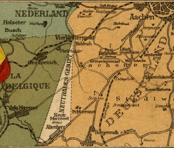
A small country, but the quality of life was just right: Following Napoleon’s defeats in 1813 and 1814, the Allies decided on a reorganization of Europe that specifically provided for the allocation of the northern part of the French Empire to the Netherlands and Prussia. When the borders between these two states were being defined, the calamine deposits in Altenberg, in the Kelmis (La Calamine) area, became a point of contention. These deposits were very important for brass production at the time. An unusual solution was found that would last for many years: a territory was established that was subject to joint administration, i.e., “neutralized”—hence the later name Neutral-Moresnet.
 © Museum Vieille Montagne
This area, which covered just 350 hectares, stretched in an almost pie-slice-shaped layout from today’s Three-Country Point to Lütticher Straße. The perfectly straight boundary lines showed that the arrangement had been drawn up on a drafting board, and both the western and eastern parts of the municipality of Moresnet were excluded from the agreement.
Liquor Smuggling: In 1816 there were only 256 residents living in Neutral-Moresnet, but this number grew rapidly with the development of the zinc mine (known since 1837 as the “Société des Mines et Fonderies de Zinc de la Vieille Montagne”) and the resulting economic boom. In 1830 the population was recorded at 500; by 1858 it had reached 2,572. The residents of Neutral-Moresnet were permitted to distill spirits—albeit only for their own consumption. However, such large quantities were produced that they could not be consumed even in the area’s up to 70 cafés and taverns. Considerable amounts were smuggled across the border, mostly into the Netherlands.
Another curious fact: At the beginning of the 20th century, the followers of the international constructed language Esperanto wanted to turn Neutral-Moresnet into an Esperanto state. At a conference of the World Esperanto Association, Moresnet was proclaimed the headquarters of the movement. According to a report in the Aachener Post, the residents of Neutral-Moresnet were enthusiastic Esperantists: “The language courses were overflowing, and everywhere you could hear nothing but broken Esperanto; the town’s 75 innkeepers did their part and operated under names in the new national language.”
Calamine mining at the Altenberg mine came to an end in 1895 Two years later the residents of Neutral-Moresnet submitted a petition requesting that the area be annexed to Belgium in the event that its independence should come to an end. During World War I, the area, like Belgium, was occupied by Germany and, under the Treaty of Versailles in 1919, was incorporated into the Kingdom of Belgium.
Discover the borderline and boundary markers of Neutral-Moresnet:
Mining, Lead, and Zinc
Plombières and Kelmis
It’s hard to believe, but the European Three-Country region is a traditional mining area. Today there are hardly any visible traces of its industrial past, but in some places you can still find them. In the Belgian municipalities of Kelmis and Plombières, lead and zinc ores were the primary minerals mined, while on the German and Dutch sides the focus was mainly on hard coal. Today’s Kelmis—formerly part of Neutral-Moresnet—is the birthplace of the modern zinc industry. It was home to the largest zinc ore deposit in Central Europe, and therefore place where local, world, and industrial history are inextricably linked. The Vieille Montagne Museum in Kelmis provides information about the town’s unique history.
Not only zinc ore but also lead and even silver were mined in the neighboring town of Plombières. You can discover the exciting past of the town and its local mining industry on a round trip at the Site Minier and in the Maison du Site Minier mining museum.
Fun fact: The names of both municipalities refer to the local mineral resources: The German name for Plombières is Bleyberg (“Lead Hill”), and in the local dialect, zinc ore is called “Kelms,” from which the name Kelmis is derived.The Name “Calamine”
Calamine is a collective term for sulfur-free zinc ores. Until 1805 calamine was used to produce brass (an alloy of copper and zinc) and was supplied to the “Dinandiers”—or coppersmiths—along the Meuse River in Dinant, Bouvignes, and Namur, as well as in Aachen and Stolberg. Starting in the 15th century, calamine from our Eurepean Three-Country region was even shipped as far as Nuremberg, Sweden, and Lorraine. In the 19th century zinc could be extracted from calamine. The zinc was used in the manufacture of sheet metal, gutters, bathtubs, buckets, washboards and cornices. Due to its versatility, zinc can also be described as the “plastic of the 19th century.” The significance of these deposits for industrial production at the time can also be seen in the establishment of the microstate of Neutral-Moresnet.
Mining since the 14th Century
The largest mining sites in the border region were the Altenberg Mountain (“Vieille Montagne” or “Old Mountain”), the Schmalgraf Mine in the municipality of Kelmis, and the Bleyberg Mine in neighboring Plombières. Mining at the Altenberg Mountain took place from at least 1344 until the deposit was completely depleted in 1884. The Schmalgraf mine produced zinc ore from 1869 to 1933. Lead mining took place in Plombières from the mid-14th century until 1922.
Rare calamine flora
Both in Kelmis (at Casinoweiher Reservoir and Altenberg Mountain Nature Reserve) and in Plombières, the former mining areas are still covered by the rare and sensitive calamine flora. These plants are adapted to soils containing heavy metals. Over the course of their evolution they have developed a high tolerance for these metals and can grow in soils that are toxic to other plants. The geographic range of the calamine flora is very limited. A typical representative of this flora is the calamine violet, whose yellow variety is found exclusively in this local border region. The calamine flora also includes the white-flowering calamine hyssop, the pink-flowering calamine thrift, and calamine fescue, a blue-green, bristly grass.
Discover Mining History:
Pilgrimages and Church Trails
Journeys in the Name of Faith
In the border region there is ample evidence of the development of a vibrant pilgrimage tradition.
The first pilgrims arrived in Aachen as early as the time of Charlemagne. In the Middle Ages the Aachen Pilgrimage became the most important pilgrimage in the German-speaking world. Although its significance declined in the 17th century as a result of the Reformation, even today numerous believers come to see the relics in the Shrine of Our Lady, which is opened only once every seven years. During the 2023 pilgrimage 110,000 pilgrims flocked to Aachen Cathedral.
In Aachen, on Preusweg, lies the starting point for the Moresnet Pilgrimage Path, an eight-kilometer route to the Marian pilgrimage site of Moresnet-Chapelle, which is also a section of the Path of St. James to Santiago de Compostela.
Moresnet-Chapelle
Moresnet-Chapelle became a destination for pilgrims due to the legend that in 1747 a farm boy was cured of epilepsy by venerating a statue of the Virgin Mary in that place. Peter Arnold Frank, who was six years old at the time, had previously made the pilgrimage to the shrine in Aachen, but touching the relics there had not alleviated his illness. In 1823 a chapel was built for the first time at the site of the healing. A few years later the first pilgrimage from Aachen was organized. Since then, pilgrims have made their way to Moresnet-Chapelle every Wednesday morning, passing numerous wayside crosses along the way. In 1830 the first church-organized pilgrimage took place, and with the consecration of the chapel the site received official ecclesiastical recognition as a place of pilgrimage. A few years later, monks constructed a Way of the Cross (Calvary) with 14 stations next to the chapel—one of the most beautiful sites of its kind in Europe. Today’s pilgrimage church stands on the site where the statue of the Virgin Mary was located in the 18th century.
Paths on the Way of St James
The pilgrimage route from Aachen to Moresnet-Chapelle is also part of the Way of St. James. Between the Rhine and the Meuse rivers the Way of St James runs in ten sections: on the Dutch side from Millingen aan de Rijn (NL), past the Niers River, to Kevelaer and on to Venlo and then along the Meuse River through Roermond to Maastricht. The routes from Aachen via Gulpen to Maastricht or Meersen connect to the Way of St. James on the German side, leading from Wuppertal via Cologne and Düren to Aachen. Aachen is also the starting point for the “Niederstraße” (low-lying route) that leads via Paris to Tours and on to the Pyrenees.
Discover the Moresnet Pilgrimage Path and the Way of St James:
Geusenweg
Those who followed Luther’s teachings did not have an easy time in the 17th and 18th centuries. In this border region dominated by Catholics, Protestants were subjected to constant persecution. This is hardly surprising, given that the entire area was under the influence of the Spanish—and thus strictly Catholic—crown. Nobles and high-ranking citizens submitted petitions seeking religious freedom. But Protestants also had to endure being called “Geusen” (from the French “gueux,” meaning “beggars”).Finally, after the Eighty Years’ War (1568–1648), the Dutch freed themselves from Spanish rule. Within their territory Protestant congregations were permitted to practice their religion freely. Vaals became a refuge in a predominantly Catholic region, and every Sunday Protestant worshippers came from as far away as Aachen, Burtscheid and Eupen to attend services. By 1750 the small village of Vaals had only twelve houses and a predominantly Catholic population, yet it boasted four Protestant churches.
The Geusenweg trail allows visitors to retrace the pilgrimage route undertaken by the French-Walloon community from Eupen. The journey took four hours along the hidden, inhospitable path through Kelmis and the Preusswald to the “Franse keresch” in Vaals.
Discover the Geusenweg:
- BorderTrail 1 · Raeren–Orsbach Axis
- BorderTrail 4 · Defense Trench
- Node network points: B: 86 (B) – D: 39 – 29 – 12
West Embankment
The integrated troublemaker
Built as a deterrent — now a habitat for endangered animals and plants
The West Embankment is a remnant of Nazi Germany’s war policy that has been preserved as a landmark in many locations throughout the Aachen region. It consisted of a system of tank barriers, tunnels, trenches, and fortified bunkers. The west embankment was built between Kleve and Weil am Rhein over a distance of approximately 630 kilometers—with a total of 18,000 bunkers and tunnels. Although it was acclaimed by Hitler’s followers as the greatest fortification of all time, the embankment played no significant role in the fighting at the end of World War II.
The embankment was primarily constructed in the years 1938–39. It consisted of a small concrete wall topped with barbed wire and humps. The reinforced concrete obstacles were adapted to the topography of the landscape and were intended to halt advancing vehicles and tanks. Each kilometer of mounds required 104 metric tons of iron and 2,000 cubic meters of concrete.
In the Aachen region the fortifications were built parallel to the borders with Belgium and the Netherlands. Most of the bunkers were demolished after the war ended, but almost 90 percent of the mounds remain intact. They are protected as historical monuments, and over time have become a refuge for many rare plants and animals.
Discover the West Embankment:
Smuggling
Firing Orders for Customs Officers
Almost everyone smuggled in the border region - out of necessity or for high profits.
Smuggling is a common occurrence in border regions when the cross-border price differences for certain goods are sufficiently large. It was the same in the Aachen area, where the illegal transport of goods was already flourishing before World War I. Even back then, people are said to have made a living as regular “border crossers,” buying large quantities of coffee cheaply in Vaals and then reselling it at a profit in Aachen.
Smuggling intensified during the general state of hardship following World War I, with more foodstuffs for daily needs now being brought across the borders illegally. Over time an almost professional smuggling operation took root. The goods were sold deep into the German Reich, and Aachen was widely known as the “hole in the West.”
Smuggling took on new dimensions in the years following World War II. To improve their living conditions, people of all ages smuggled goods across the Belgian and Dutch borders into Germany. In May 1945 the border crossings were closed, and the British occupying forces installed a German customs administration, which was later even given orders to shoot. As a result, some smugglers did indeed lose their lives at the border.
Barbed-wire fences along the borders
The most popular smuggling goods were primarily coffee, tea, butter, cocoa, and cigarettes. Their export and import were restricted, and every trip across the border was documented with a stamp in the traveler’s passport. To prevent anyone from crossing the border with goods outside the official crossing points, the border was largely lined with barbed-wire fences.
Before the currency reform on the 20th of June 1948, the German Reichsmark was still in use. A kilogram of coffee could cost up to 1,500 German Reichsmarks, a pound of butter 600 Reichsmarks, and a single American cigarette as much as eight Reichsmarks. Considering that a German customs officer earned 180 Reichsmarks a month at the time, it becomes clear just how lucrative smuggling could be.
Ferns as “smugglers' grass”
In the Aachen Forest, as soon as customs officials came into view, smugglers would often use the dense fern growth to conceal their goods and themselves. That is why ferns are still referred to as “smugglers’ grass”. The railroad line from Aachen to Montzen—and especially the tunnel along the route—was frequently used as a smuggling route, as was the Moresnet Pilgrimage Path through the Preuswald Forest, where smugglers often mingled among the pilgrims.
Discover the Smugglers' Trails:
Historic Vaals
In the Footsteps of Clermont
How a successful textile manufacturer from Aachen made Vaals his home.
The area around Vaals was settled long before the first century and people lived there during the Roman period. However, the town owes its current appearance largely to the efforts of one man: Johann Arnold von Clermont (1728–1795). The son of an Aachen textile manufacturer, Clermont moved his family business’ production to the neighboring town in 1761 after the imperial city’s guild laws had prevented the expansion of manufacturing. At that time Protestants were welcomed in Vaals, and many of Clermont’s fellow Protestants from Aachen also moved to the Dutch part of the Duchy of Limburg, as they faced discrimination in Catholic Aachen.
Clermont left his mark in Vaals
On Clermont Square in the town center, he commissioned the Aachen-based architect Moretti to build a city mansion with a textile factory. Today the Vaals municipal administration is headquartered there.
Clermont also initiated the construction of a large public water facility that was part of the canal system of the “Gau” stream: With its constant temperature of 10 degrees Celsius, the soft spring water was ideal for rinsing and dyeing fabrics.
Clermont Square is also home to the former Protestant church. It was built in 1737 by wealthy Protestants from Aachen. Today the octagonal building houses the “Kopermolen” (copper mill) Museum, which hosts temporary exhibitions and concerts.
Early Classical Splendor
The magnificent early Classical building of Kasteel Bloemendaal Estate also traces its origins to Arnold von Clermont. In 1791 at the age of 63 the manufacturer decided to fulfill his lifelong dream and had the cornerstone laid for a princely country estate across from his new weaving mill. Later the house became a monastery and a monastic boarding school, and during World War II the German occupiers used it as a military hospital. In 1990, when the vacant historic building was in danger of falling into disrepair, the decision was made to convert it into a luxurious castle hotel.
Vaalsbroek: “One of the most beautiful villages”
Clermont also acquired the dilapidated noble estate Vaalsbroek and gradually converted the remains of the building into his country estate, complete with a residence, office wing, manufacturing facility, and landscaped park. Adolph Vaessen, the chaplain of Vaals, wrote about Clermont’s further achievements, noting that the textile manufacturer had “embellished this place with so many other buildings and residences that it was thereby transformed from a formerly marshy village dotted with shabby huts into one of the most beautiful villages in the area.” Today the building houses a luxurious country hotel.
Tip: The marked walking tour “Historische Stadswandeling” (historic city tour) through historic Vaals features small signs in Dutch providing information about selected buildings.
Discover Vaals: